 |
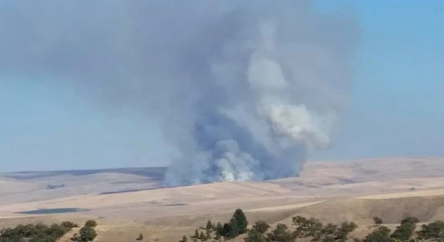
| Long Hollow Fire |
95% Contained. 33,451 Acres reported. 7/31/18 Fishing Report
7/31/18
"The Deschutes River is open for recreational activities. The Deschutes River access road and Highway 216 are open. The Deschutes River evacuation level in Segment 3 (Buckhollow to Mack’s Canyon) was lifted Monday July 30th.
Northwest Incident Management Team #10 will transition management of the fire to local firefighting resources under the leadership of Mike Moss, at 6:00 am on Wednesday. A local 20 person hand crew currently working on the fire will remain. Personnel will be located at Grass Valley. Additional resources will continue to be available if needed."
7/30/18
75% Contained
7/29/18 Updates
Total personnel on scene - 235. 58% containment. Fire size is up to 34,550 acres.
"Most of the fire is displaying minimal fire behavior. The southeast corner is slightly more active, and has a greater brush component. Bucket drops were conducted in this area."
Evening of 7/28/18
3 % Contained. 33,000 Acres.
Afternoon of 7/28/18
Just when you thought it couldn't get any worse: Extreme wind driven runs uphill have proven to be a difficult contributing factor. The most current map of the boundary of the Long Hollow Fire - Note it jumped the Deschutes from west to east, apparently some time last night was the word we got. The only portion of the lower 40 miles of the Deschutes that is not black is from Macks Canyon to just upstream from Jones Canyon, which isn't 'much. This fire burned up against the southwestern limit of the Substation Fire on it's northwest flank. 145 people are reported to be working on this fire.
Morning of 7/28/18
Fire is now 18,293 acres.
"Extreme fire behavior. Brush and grass. Evacuation in effect. Road, trail, and area closures. Residences, ranches, town of Grass Valley, national infrastructure, agriculture, and recreation threatened."
As of 7:00PM - 7/27/18
What we know: Columbia Gorge Fires facebook page reports Long Hollow Fire now (updated) around 17,000 acres in size. The fire started by farming equipment. Fire has spread along west side of the Deschutes River in the areas between Macks Canyon to the north and Beavertail to the south.
"Closures and Restrictions: The area along the river is closed to the public. The 216 Road from Buck Hollow River Access to the Macks Canyon Campground is closed. The area is also under Industrial Fire Protection Level III. Roadblocks have been set up by local law enforcement."
As of 5:45PM
According to Wasco County Sheriff's Office facebook page (at least for now): The community of Boyd is at level 1 - get ready - due to fire activity in the area.
As of 7/27/18Limited Deschutes River access right now during #LongHollowFire. No public access of any kind is allowed in Segment 3 (Buckhollow to Macks Canyon). Boaters in Segment 4 can stay on river but there is no road access from Hwy 216 north to Macks Canyon. pic.twitter.com/5Q01f6DrRj— Central OR Fire Info (@CentralORFire) July 27, 2018
16,000 acres. 0% containment. Arizona IMT3 mobilizing. Evacuations in effect.Currently reporting 63 people on scene, fire is burning along the lower Deschutes River with potential continued spread east. Weather concerns include High temperatures with low relative humidity.
 |
| Photo Credit: BLM |
As of 7/26/18
Wildfire located between Dufur and the Deschutes River near Boyd, Oregon south east of The Dalles. As of 8PM the estimated size was at 5,000 acres however by 8:41PM the reports stated 6300 acres.
"8 pm : Sheriff Magill has issued a level 3 evacuation along the Deschutes River from Shearers Falls to Mack’s Canyon. Level 3: Go Now.
Fire has been growing and traveling SE, likely to jump the Descartes."
More info to follow soon
 |
| Photo: Mid-Columbia Firefighters #midcolumbiafirefighters |
"The Gorge"
Gorge Fly Shop Team - 541.386.6977


No comments :
Post a Comment